Climate
 The Philippines has a humid equatorial climate characterized by high temperatures and heavy rainfall. There are four recognized types of climates based on the distribution of rain (see below). The two main seasons are the wet or rainy season (June – November) and dry (less rainy, December – May). The later is sometimes subdivided further into the cool dry season (December – February) and the hot dry season (March – May). The warmest months of the year are generally between March and October and the coolest between November and February.
Temperature
Based on measurement of all weather stations in the Philippines (except Baguio), the average year-round temperature of the country is 26.6℃ (79.9 ℉). Cooler days are usually experienced in January with an average temperature of 25.5 ℃ (77.9 ℉). Warmer days, on the other hand, are experienced in May with an average temperature of 28.3 ℃ (82.9 ℉). Baguio, due to its elevation of 1,500m (4,900ft) above sea level, has an average temperature of 18.3℃ (64.9 ℉). Temperatures can fluctuate between regions, seasons and El Niño/La Niña effects, however January is generally the coolest month while May is the warmest.
Latitude is an insignificant factor in the variation of temperature while altitude shows greater contrast in temperature. Thus, the mean annual temperature of Baguio with an elevation of 1,500 meters is 18.3 ℃. This makes its temperature comparable with those in a temperate climate. Because of this, it is known as the summer capital of the Philippines.
The mean annual temperature of the southernmost station in Zamboanga and that of the northernmost station in Laoag is almost the same. In other words, there is essentially no difference in the mean annual temperature of places in Luzon, Visayas or Mindanao measured at or near sea level.
Humidity
Humidity is the amount of water vapor in the air while relative humidity is the percentage of water vapor in the air at a given temperature. Relative humidity in the Philippines is high, often averaging around 80% in many parts of the country, making the hot temperatures feel hotter. The high relative humidity is due to three factors: the evaporation from the seas surrounding the country, different prevailing winds in the different seasons of the year and high rainfall amounts. It’s not the temperature that makes you feel uncomfortable, but rather the humidity.
Climate Types
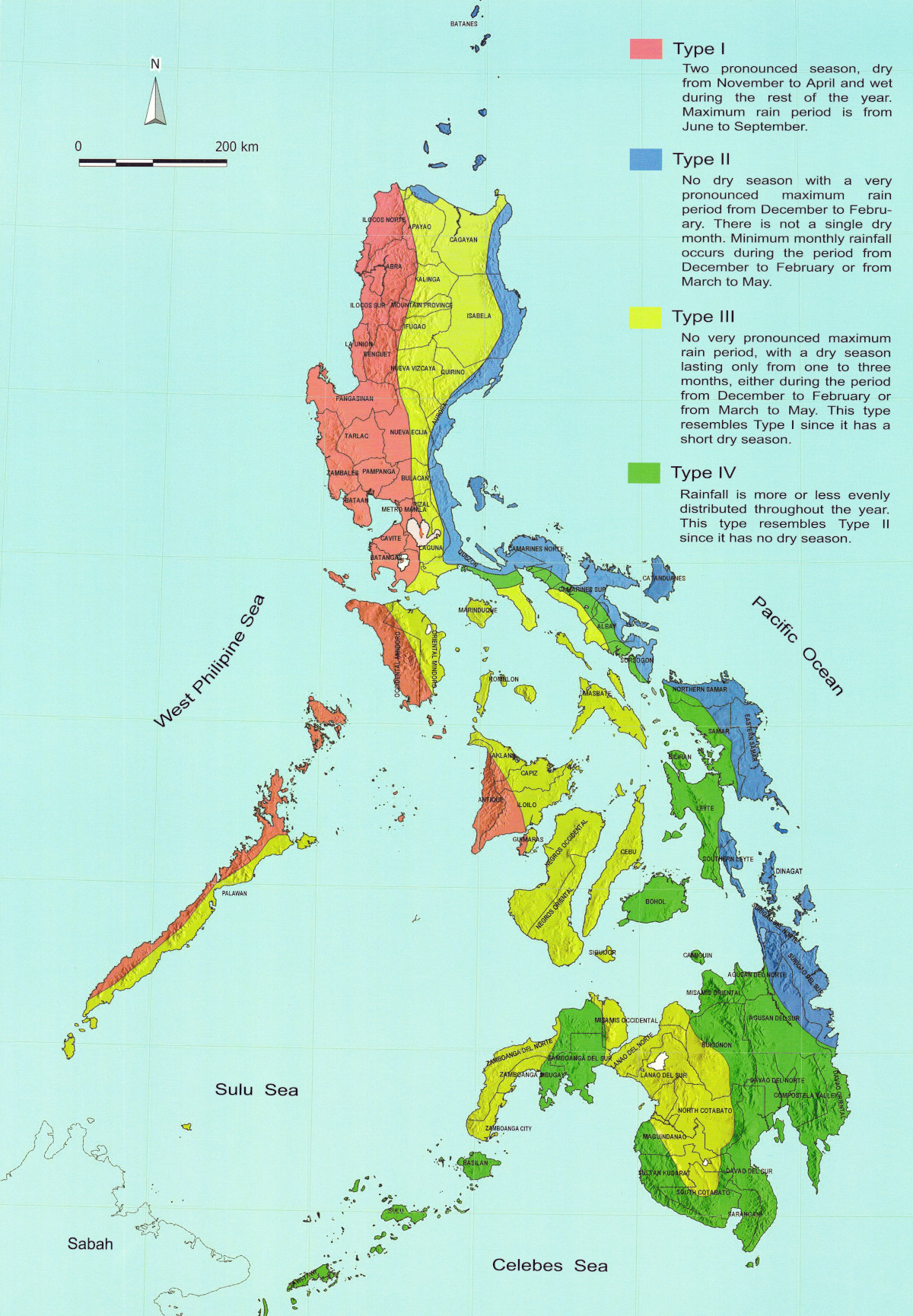
There are four recognized climate types in the Philippines based on the distribution of rainfall (see above clickable map):
- Type I: Two pronounced seasons: dry from November to April and wet during the rest of the year.
- Type II: No dry season with a pronounced rainfall from November to January
- Type III: Seasons are not very pronounced, relatively dry from November to April, and wet during the rest of the year.
- Type IV: Rainfall is more or less evenly distributed throughout the year.
These seasons can change significantly due to the effects of El Niño or La Niña effects (see below). El Niño tends to bring dryer weather and sometimes even droughts. La Niña is the opposite weather pattern and tends to bring more rainfall and sometimes flooding.
Monsoons and Rainfall
A monsoon is a major wind system that seasonally reverses its direction in a region. The Philippines experiences two kinds of monsoons — the northeast monsoon and the southwest monsoon in the summer. The intensity and duration of the monsoons vary from year to year.
The northeast monsoon, commonly called Amihan, affects the eastern part of the country from October to late March. A cold, dry air mass coming from Siberia and China gathers moisture over the Pacific Ocean before reaching the eastern parts of the country. It brings slight to moderate rainfall but sometimes is associated with drought in the affected region. This period is considered the best time to visit as temperatures, humidity and rainfall are all lower.
The southwest monsoon, commonly called Habagat affects the western part of the country from June through September. It is characterized by heavy rains that can last for a week at a time. Temperature and humidity levels are also higher during this period. The gusty winds from the west and excessive rainfall can turn into dangerous typhoons.
Rainfall distribution throughout the Philippines varies from one region to another, depending upon the direction of the monsoon and the location of the mountain systems.
The mean annual rainfall of the Philippines varies from 965 to 4,064 millimeters annually. Baguio City, eastern Samar, and eastern Surigao receive the greatest amount of rainfall while the southern portion of Cotabato receives the least amount of rain. At General Santos City in Cotabato, the average annual rainfall is only 978 millimeters.
Typhoons
Typhoons (locally known as Bagyo have a great influence on the climate and weather conditions of the Philippines. Much of the rainfall, humidity and cloudiness are due to their influence. Most originate in the region of the Marianas and Caroline Islands of the Pacific Ocean having the same latitude as Mindanao. Their movements follow a northwesterly direction, sparing Mindanao from being directly hit by most typhoons that cross the country.
Approximately 20 typhoons enter the Philippine Area of Responsibility each year, with at least 10 expected to make landfall. Of these 5 are are often destructive and powerful. The months of June through September are the most active months, with August being the most activite. They normally account for at least 30 percent of the annual rainfall in the northern Philippines while being responsible for less than 10 percent of the annual rainfall in the southern islands.
PAGASA gives local names to typhoons that enter its area of responsibility. This is in addition to the name typhoons are known by internationally. This usually results in typhoons carrying two names: an international name and a local name used within the Philippines. This two-name scheme is still followed today.
El Niño and La Niña Effects
El Niño and La Niña are climate patterns in the Pacific Ocean that can affect weather worldwide. During normal conditions, Pacific trade winds blow west along the equator, taking warm water from South America towards Asia. To replace that warm water, cold water rises from the depths – a process called upwelling. El Niño and La Niña are two opposing climate patterns that break these normal conditions. Scientists call these phenomena the El Niño – Southern Oscillation (ENSO) cycle. Episodes of El Niño and La Niña typically last nine to 12 months, but can sometimes last for years. El Niño and La Niña events occur every two to seven years, on average, but they don’t occur on a regular schedule. Generally, El Niño occurs more frequently than La Niña.
During El Niño, trade winds weaken and warm water is pushed east, toward the west coast of the Americas. During La Niña events, trade winds are even stronger than usual, pushing more warm water toward Asia.
In the Philippines, El Niño events tend to create dryer weather and can result in drought. La Niña events are the opposite with increased rainfall expected. Both of these events, when they occur, tend to disrupt the normally expected climate in the region.
PAGASA
The Philippine Atmospheric, Geophysical and Astronomical Services Administration (PAGASA) is the state weather agency of the Philippines. It monitors daily rainfall and temperature data together with monthly observation of standard precipitation index, soil moisture, runoff and vegetation. It works with the World Meteorological Organization (WMO) Regional Climate Centres (RCC) network node for climate monitoring in Southeast Asia. Climate prediction is also offered by PAGASA.
PAGASA monitors tropical cyclone activity and issues warnings if they fall within the Philippine Area of Responsibility (PAR). Tropical cyclone bulletins are issued by PAGASA every three hours for all tropical cyclones within this area that are currently affecting the country, six hours when cyclones are anticipated to make landfall within the Philippines, or twelve hours when cyclones are not affecting land.
Several of the reports and monitoring that PAGASA provides can be found below in the References section.
Tropical Cyclone Wind Signal
A Tropical Cyclone Wind Signal (TCWS), also known as a Public Storm Warning Signal, is a plain text warning to particular land area that may experience winds of at least strong breeze in strength on the Beaufort Scale (i.e., 39 km/h, 22 kt or higher) within at most 36 hours from the time the signal is put into effect during the passage of a tropical cyclone. A particular wind signal has an equivalent expected wind threat, length of time (in hours) before onset of expected wind threat, and potential impacts to the locality. The current TCWS system uses five (5) levels of wind signals that are numbered from 1 to 5, with a higher signal number associated with higher general wind strength and shorter warning lead time.
The following summarize the PAGASA Tropical Cyclone Intensity and Wind Signals:
- Signal #1, Tropical Depression (TD): winds of 39 – 61 km/h (21 -33 kn; 24 – 38 mph) are prevailing or expected to occur within 36 hours
- Signal #2, Tropical Storm (TS): winds of 62 – 88 km/h (33 – 48 kn; 39 – 55 mph) are prevailing or expected to occur within 24 hours
- Signal #3, Severe Tropical Storm (STS): winds of 89 – 117 km/h (48 – 63 kn; 55 – 73 mph) are prevailing or expected to occur within 18 hours
- Signal #4, Typhoon (TY): winds of 118 – 184 km/h (64 – 99 kn; 73 – 114 mph) are prevailing or expected to occur within 12 hours
- Signal #5, Super Typhoon (STY): winds of 185 km/h (100 kn; 115 mph) or greater are prevailing or expected to occur within 12 hours
References
- Climate – Philippines – Climates To Travel
- Climate and Average Weather in Philippines – Weather and Climate
- A Climatological Analysis of the Southwest Monsoon Rainfall in the Philippines – Science Direct
- Climate Map of the Philippines (1951 – 2010) – PAGASA/DOST, WikiMedia
- Climate of the Philippines – Wikipedia
- El Niño – Wikipedia
- El Niño & La Niña (El Niño-Southern Oscillation) – Climate.GOV (NOAA)
- Monsoon – Britannica
- Monsoon – National Geographic
- PAGASA – Wikipedia
- Typhoons in the Philippines – Wikipedia
- WestPacWX – Great Weather Site for the Philippines and the Western Pacific
- What are El Niño and La Niña? – NOAA: National Oceanic and Atmospheric Administration
- What is El Niño? – Pacific Marine Environmental Laboratory (NOAA)
- What is La Niña? – Pacific Marine Environmental Laboratory (NOAA)
- What is the El Niño–Southern Oscillation (ENSO) in a Nutshell? – Climate.GOV (NOAA)


